![]()
![]()
![]()
1928 earthquakes
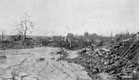  |
Two of the largest earthquakes during 20th century in Europe happened in a period of four days in April 1928. Several towns and hundreds of villages were destroyed in South Bulgaria. |
 |
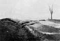
The geologists Georgy Bonchev and Stefan Bonchev visited the Chirpan region after April 14th 1928 earthquake. They described and mapped all ruptures and cracks on the surface produced by that event and by next April 18th 1928 earthquake. They worked independently and mapped north main rupture in different ways. |
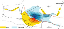 |
Levelling networks were measured during 1923–1926. Changes of the surface after the two earthquakes were established by new geodetic measurements in 1929–1930. The largest displacement was recorded along south rupture, whereas displacement along northern rupture (April 14th) reached 0.3–0.5 m. |